
Larger size
First of all, I would like to apologize for not updating this for a week. This was a very busy and hectic week and Jim was going to post some food things up but unfortunately stuff came up for him as well and he was unable. None the less, I would like to rectify this situation and work harder to update with new and interesting things. If you have something you would like me to look at or think about please feel free to send me links to my email or post in any of the comments. I read a whole lot of things ever week but it takes a lot of time and as class work mounts, the time I can dedicate to keeping up with it, unfortunately is sacrificed. Without further ado, I present you the usual friday infrastructure post, but new and improved on a sunday (yeah it will happen again, but I will try to not let it)
Today we are across the channel and down the coast to Barcelona! Quite a wonderful city, very bikable with a nice bike share, but only for city residents last I checked. They also have a very nice metro/tram transport system that is laid out nicely and with easy to read signage. Of note, I do not read Spanish nor do I speak any of it, however I was able to find my way around quite nicely. That may have been due to the amazingly useful google maps and google street view but none the less. There was a great organic vegan restaurant hidden on a back street I found which was simply amazing, I will do a post on them later this week, once I find them again.

The tram lines in Barcelona are separate from the underground metro lines, they do however connect in and form a nicely integrated system. Tram lines can be found on the western edge of the city and these are lines T1, T2, and T3 (yes the “T” is for Tram) in the Eastern side the lines are T4, T5, T6. to get from either end of the lines, a subway must be taken and unfortunately 2 transfers must be made, but the system was not designed to work tram-tram it was designed to fit into the subway system and to integrate that system better into the urban environment.
The line that I followed and took pictures of is the T4 line which starts (or ends? or both!) at the Olympic Village near the waterfront. Pictured below is the google street view of this.

Larger size
Note it is a duel line system running both ways next to each other. The end is concrete, however it changes to grass fill very quickly as you move north along the edge of the “Parc de la Ciutadella” which houses a zoo, museums, a 1700’s citadel (for which the park is named), as well as water displays, walking and biking paths and planned gardens. Its very nice, lots of people were out the day I was there.
 Although not in this picture...
Larger size
In this picture note the markings on the road showing the space the tram takes up when it is moving through the intersection. There is a great deal of space given to make sure that a car or lorrie is not ending up stuck on the rails.

Larger size
I would like to point out the bike share scheme in Barcelona, Bicing , the system is for residents only and consists of 3000 bicycles throughout the region. It has been in place for 3 years now and has been quite successful. Of note these are the same bikes (practically) that are used for the “SmartBike DC” bike share scheme.

larger size
Bicing website, in spainish

larger size
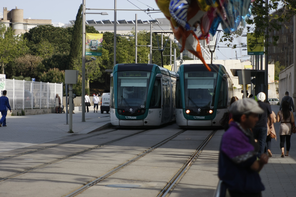
There are 4 elements I would like to mention regarding this image. One, note the bike lane on the right hand side in the sidewalk. The lane is stripped and is “one way” in the direction of car travel. While this is not ideal, the sidewalk space is large enough to accommodate this lane and mixing does not seem to be too much of a problem. Two, note there is no car parking along this boulevard, but there are trees and it is common to see mopeds and bicycles chained up to these as impromptu parking. It would have been simple to put in staple racks between them, like Vienna did, however it works, I guess… Three, note the ground painting on the lower left, the arrow points in the direction to look first for oncoming trams, very useful especially as it is in the opposite direction of the cars. Four, note the space between the road and the rails. This is good to have for people who cross the road and have to wait for the tram. I am unsure if the road and tram walking lights are timed and triggered together, it would be smart if they were but I have no idea. This space also provides access to the tram stations in the center of the road, these are on slightly raised platforms as the trams are the traditional modern European low floor design, and as such the debarking height is not much more then the normal sidewalk. It would be nice to se a bollard of some kind on the corner of the cross walk next to the tram tracks for a bit of protection from automobiles , but it is not really critical.
To get back to the main image, it is taken at the Olympic park stop end, I can tell this due to its timestamp when I took it, however I have no idea where exactly or where I am looking to see solar panels on the roof, as can be seen in the upper center. I really enjoyed Barcelona and wished I had spent more time there and not gone on, I only spent one full day, and it was certainly not enough.
Google Maps
Transports metropolitans de Barcelona network map (in pdf)


No comments:
Post a Comment