Showing posts with label yorkshire. Show all posts

Saturday, September 12, 2009

Friday Infrastructure: A jaunt to York


Larger size

Yep late again, fell asleep last night and meant to write this then, whoops!

Today we are showcasing something a little bit different. As you might have figured out I really like focusing on cycling and walking and using them as a viable means of transportation. However, these 2 cannot solve all our problems, in fact for many places a car is still needed in some form and distribution is needed to be done by trucks in some cases as well. That is where electric drive comes in, however for long distances there is another piece to this puzzle, which are the Railroads.

I am a huge train nut, not an avid train spotter, but I would be if I had the time. So one of the wonderful things about the city of York, UK is, yes it’s a cycling “capital” (I use that term loosely because really its still not really great for infrastructure, just better then non existent.) It is also the home of the largest train museum in the world and a vital link between London and Edinburgh being ~2 hours and 200 miles from each.

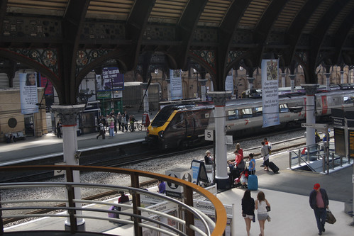
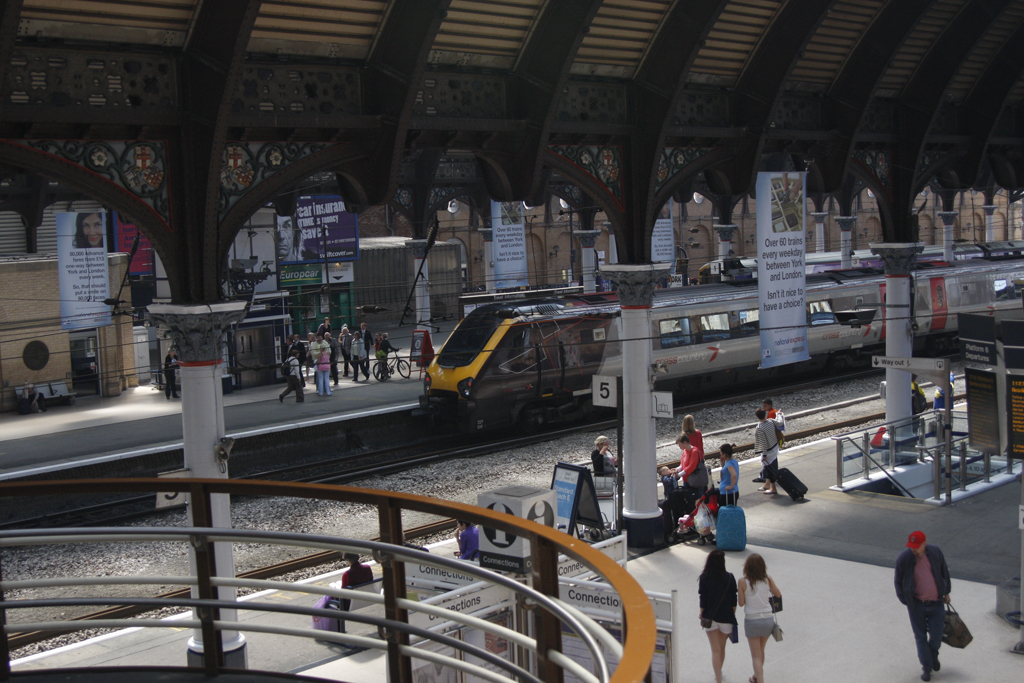
The picture for today is indeed a picture of York rail station, built in 1877 it is quite distinct and holding up well, but could use a bit of updating. They do have some bike storage and it was full when I saw it, but its very small and nothing to shake a stick at.

One might notice the sign hanging in the picture, it notes over 60 trains a day to London from this station and going online to the East Coast line website the time for some of these trains varies from just under 2 hours to about 2 hours and 10. It is ~190 miles from York station to London Kings Cross station.

For reference the distance is about the same from Boston South station to NYC grand central. There are 10 trains a day here with the regional taking 4 and a half hours and the Acela taking 3 and a half. Which is quite sad if you think about it, the Acela has a higher top speed than any of the British trains but the rails here are so bad and there are too many stops along the way that it never reaches any good speed, not the mention they had to skimp on the breaks to save money so it can’t even go its top designed speed.

It is hard to give fair information because in the uk prices are hugely dependent on how far ahead you can book. For my time in the uk I was able to book about a month+ in advance and were getting £15 fares for a whole lot of travels, I also had a 30% off discount card. The trip to London from York can cost anywhere from £11(17$) to £96(153$) with the lower fares on odd hour trains. To compare the Acela will cost lowest 93$(£58) to 124$(£83) one way and business class only. There is seriously something wrong here….

If they were truly serious about the Acela then 1 maybe 2 stops, in the uk there are 4 stops on most trains between London and York, if you needed more you take a slower regional which makes sense. There are currently 6 stops between Boston and New York for the Acela.

There is not much I can say about the station, it does its job and its great to be able to take the rails pretty much anywhere anytime in the UK. I wish I had that option here. There will be more later on how the UK system works and what I don't like about it and how it is currently run.

Google Maps
Sustrans map

Amtrak
National Express East Coast
York Station
City of York

Friday, July 24, 2009

Friday Feature, End of the Line


welcome back! For today I am featuring one of the problem spots I found when cycling around West Yorkshire. The trail is the National Cycling Route 66 or the Leeds-Liverpool Canal, which also happens to be part of the thousands of miles of restored canal work by British Waterways. It also turns into cycling route 69 around the town of Saltaire, which is known for the Salts Mill art complex, some really good stuff up by David Hockney, whose photography happens to have inspired a number of my works, as well as a wonderful café (if a bit pricy, but its local and some organic bits so worth it). The Saltaire rail station is right next to the cycle route and the Salts Mill complex as well so makes for ease of mode transfer if so desired.
Back to the image though, (sorry I get easily distracted by little tidbits and such) this is taken a little bit after route 69 goes on road for the official route part. The section I am on is part of a continued purposed (car)traffic-free rout to replace(I think) the on-road section of 69 into Silsden. This traffic free route is purposed currently to continue all the way north to Skipton following the Leeds-Liverpool Canal. I should note at the time I made this trip I was not aware of Sustrans live map feature (so useful) and thus didn't really know where I was going, or how the route split off at this point, or where I would end up either. I had cycled a bit of the route down the hill from where I lived in Kirkstall, so I knew it went north but had no idea how far. I took the southern route later on in the spring, but that's for another time.

The plan for the day was to ride until about noon or 1:00 or until I reached a town in that time window. I left around 9:20 that morning so by noon a café for a nice healthy lunch was in certainly in order. luckily I was able to do just that! I found This café around 12:30 after spying a rather large collection of houses along the waterway. needless to say a wonderful fresh made sandwich on hand-baked bread with local ingredients ensued finished up with a fresh crushed oh so amazing fruit smoothy. After taking about 30 minutes to eat and rest and look at the pictures I had taken so far I headed back home, still not knowing where I was as I had somehow missed any and all town signs.
Cafe Address

the route off the official path is about a mile and a half long and goes right between some very friendly sheep and the canal. It is very very very bumpy, I took the bike very slowly along this, she held up wonderfully though and was quite a champ! I do not recommend taking this "short cut" until they can make it officially part of the network though. Silsden is a small Yorkshire town, so the on road section did not look that bad and I think it would have been just fine and safe to cycle on it. For those of you looking at the route and are confused, you will get to the point where it says route 69 and an arrow pointing off the trail in nice official form to the left as you cycle north from Leeds, take that on road bit and follow it, it will lead right into down town Silsden. if you continue along the canal you will pass under a bridge, turn back before you do so unless you really enjoy bumps.

a collection of images I took along the official network of route 66 and route 69. I should note that it was not as quiet as it looks, while there were stretches where I didn't see anybody, I just don't typically take pictures of large groups while on my bike since I am busy making sure I let them know I am there and don't run them over.


out for a nice ride, a lock in the background
full size

never too old
full size

Lunch!!
full size

typical quality of the trail
full size

almost home
full size


Google Maps
Sustrans Map just look where the green line turns into the royal blue line near the bottom right of the screen.